
The Best Hiking Trails in Santa Clarita, California
Table of Contents
Santa Clarita, at first glance, may not seem like much. Suburbs, youth sports, and a theme park-not a place for hikers. But like most things, there is more to Santa Clarita than meets the eye. On the fringes of the sprawl lie miles of hiking trails that explore secluded canyons, geologic oddities, and local history
The city of Santa Clarita has done a wonderful job of preserving local green space. Travel to the edge of town, and hikers will find protected lands home to oak woodland, wildlife, and seclusion. The hiking is good enough that visiting these trails is one of the best things to do in Santa Clarita.
Los Angeles harbors many great, and challenging hiking trails. The trails in Santa Clarita, though, offer a little bit more seclusion. Other great hikes, like the Brush Canyon Trail to the Hollywood Sign, are not far from town. Santa Clarita has the potential to be a quieter, more low key local destination.
Santa Clarita has a trail for every hiker. Many are well known, like Towsley Canyon, and a few lie off the beaten path. Some are challenging cardio workouts, while others are a literal walk in the park. It’s not Yosemite or The Grand Canyon, but we hiked and mapped the 9 best hikes in Santa Clarita.
Related: Safe Hiking during the COVID-19 Pandemic
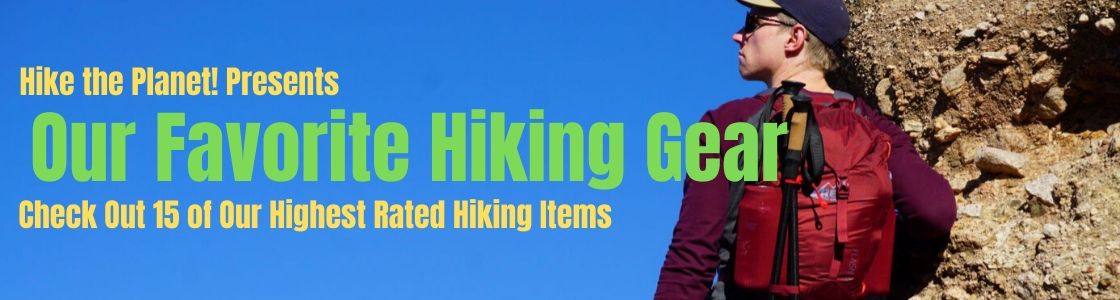
Looking For Gear? Click the Banner Below to See Our Highest Rated Hiking Gear!
Towsley Canyon

Towsley Canyon? More like Tarsly Canyon, am I right? This hike is oily-there’s black gold bubbling up from underneath. Enterprising hikers-bring a shovel. You might strike pay dirt.
Actually, this oil seepage is the whole reason that the SCV exists. Apart from all the citrus fields and cow pastures, oil was a major source of local revenue. The Newhall Land and Farming company decided to reinvest their oil profits in real estate, culminating in the planned community of Valencia.
Aside from Oil, hikers in Towsley Canyon can gain great views of Santa Clarita. A moderately difficult loop trail ascends to the top of a mountain ridge. Heading down, the trail travels a stream as it passes through a narrow slot canyon.
With two trails-one easy, and one challenging, Towsley Canyon is a great area for any hiker. To reach Towsley Canyon, take the Old Road south from Santa Clarita. Pull into Ed Davis Park, and enjoy the trails!
For More Information on Towsley Canyon, read our trip report!
Placerita Canyon

Cutting into the western end of the San Gabriel Mountains is Placerita Canyon. Placerita Canyon is an isolated, oak filled canyon, brimming with oddities-chief among them being the real place where gold was first discovered in California.
The fanciful story of gold discovery in the SCV was made up to draw tourists, or at least modified with some heavy poetic license. No doubt, gold really was discovered here in 1842, and it did bring a small gold rush to the then undeveloped Santa Clarita Valley.
But oh yeah! Hiking! Getting back on track here, Placerita Canyon does feature some excellent hiking trails. Running throughout Placerita are paths suitable for all skill levels.
Hikers can take the Manzanita Mountain Trail into the slopes above the canyon, or learn about local history along the Heritage Trail. The Nature Center hosts live, local animals, and numerous nature walks show off the beauty of Southern California.
Read more about hiking at Placerita Canyon by checking out our trip report!
Whitney Canyon and Elsmere Canyon
Located just off Newhall Avenue exit on the 14, Whitney Canyon Park is one of the most popular hiking areas in Santa Clarita. A network of trails ascends the gentle northern flank of the San Gabriel Mountains.
With trails ranging in difficulty from moderate to strenuous, hikers of all fitness levels are welcome at Whitney Canyon Park. The hiking experience at Whitney Canyon is similar to Placerita Canyon, located just a few miles up the road. There is even a spring fed waterfall!
From the top of Whitney Canyon, a panoramic view of Santa Clarita enchants hikers. Whitney canyon is easy to reach, and accessible, providing visitors a wonderful sampling of California’s biodiversity.
Read More About Whitney and Elsmere Canyons Here!
Bouquet Falls
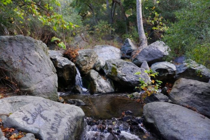
Though not much hiking is found here, Bouquet Canyon Falls is garners a spot on this list. Fed by release from the Bouquet Canyon reservoir just upstream, Bouquet Canyon Falls is a small waterfall that runs all year.
Water is rare in these parts, and a waterfall even less so. Reaching the Bouquet Falls is easy. After a winding drive up Bouquet Canyon Road, these falls are located off of a small parking lot about 1 mile south of Bouquet Reservoir. They’re easy to miss, but if you’ve reached the reservoir, you’ve gone too far.
A short walk takes you to the falls, complete with shallow pools, rocks, and oak trees. SCV and Antelope Valley residents can cool off at the falls on a hot day. Pack a picnic, and enjoy this pleasant spot, where you might even spot a deer looking for a cool drink of water.
Oh, and don’t mind all the graffiti. It’s just some local folk art.
Hikers looking for a challenge can tackle the nearby Quarry Road, which connects to a whole network of Forest Service roads ripe for exploring.
Haskell Canyon Open Space

In the Hills above Saugus, the Haskell Canyon Open Space is a quiet retreat for hikers, dog walkers, and mountain bikers. Hiking through chaparral, visitors to Haskell are awarded great views of the city.
When I was a teenager, Haskell Canyon was a favorite spot of mine. I went here to walk my dog, and to be alone. These days, Haskell is much more popular. There are more hikers here than at any time in the past, but I don’t mind. It is a good thing that people are coming here to enjoy nature, and get exercise.
Haskell Canyon is pretty cool. Following a short trail, hikers can get way above the Santa Clarita Valley. The views into the mountain ranges beyond give the feeling that you are far away from the suburbs.
One section follows a narrow box canyon. The hills close in around you, shielding you in to a secluded natural setting. Located just off Copper Hill Drive, Haskell Canyon is easy to reach for a nice afternoon hike.
Slide Mountain

As a first line of defense against wildfires, Fire Lookout towers scan the horizon, looking for smoke. Slide Mountain, located north of Santa Clarita near Pyramid Lake, hosts one such tower. The prominence of Slide Mountain allows Fire Lookouts a wide viewshed of the surrounding wilderness.
I should mention, the view from the top of Slide Mountain is astounding. Huge swathes of the Santa Clarita Valley, portions of the Antelope Valley, and even LA’s own Griffith Park, is visible. Slide Mountain is accessible via a challenging, yet well maintained trail that begins off of old Highway 99, down near Piru Creek.
Vasquez Rocks
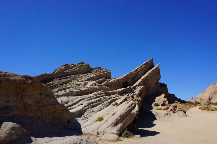
Even if you’ve never stepped foot in Vasquez Rocks before, you’ve seen it. Believe me, you have. Great moments in Pop Culture have occurred at Vasquez Rocks. Any Hollywood production that takes place in Utah, on an Alien Planet, or in the old west will use Vasquez rocks as a stand in.
Music Videos, Countless Car Commercials, and of course, Kirk vs. The Gorn, all have been filmed at these iconic rock formations. Even though production studios like to take over Vasquez Rocks on a seemingly daily basis, it is open to the public.
Long before any hikers, movie sets, or equestrians adopted Vasquez Rocks, it was the site of a Tataviam Village-the Indigenous Peoples to first call the Santa Clarita area home.
Later, Vasquez Rocks would draw it’s namesake from the infamous bandit Tiburcio Vasquez. Tiburcio was a hit in my third grade social studies class, where he was well regarded as the Robin Hood of old California.
East and Rice Canyons

Hiking East and Rice Canyons is a package deal. For the price of one parking pass, Hikers can knock out two great trails in one go!
Sitting in a lush fold near the Newhall Pass, East and Rice Canyons are similar to Towsley Canyon. Rugged, forested, and beautiful, East and Rice Canyon have fewer crowds, but better views.
Both hikes begin at the same trailhead, near shady oak groves and grassy knolls. After a short walk, Rice Canyon splits north. Hikers can follow Rice Canyon to the end, enjoying a pleasant walk in a shady, creek feed draw.
Continuing on the trail, hikers gain hundreds of feet of elevation to a ridge overlooking the city. Surrounded by a Douglas Bigcone Fir forest, hikers can gaze out to both the San Fernando Valley, and Santa Clarita Valleys. Not only are these some of the most unique trails in Santa Clarita, but they are some of the best in all of Los Angeles County!
Fish Canyon-The Best Overnight Trail
Hidden in the Mountains north of town, a long, narrow canyon drives deep into rugged wilderness. Full of history, the remote Fish Canyon Trail offers visitors a truly unique hiking experience.
Many consider Fish Canyon to be one of the best hikes near Los Angeles-high praise in light of nearby peaks. I was skeptical, but after trekking into Fish Canyon, I think that it deserves it’s reputation.
Folded into the country north of Castaic Lake, Fish Canyon begins at the end of Templin Highway. Like nearby Slide Mountain, Fish Canyon gives off a remote vibe. As you hike further into Fish Canyon, the walls narrow in and grow higher. Soon, hikers find themselves in a remote slot canyon, far removed anything else in Los Angeles.
Fish Canyon is a popular overnight hike. Many like to camp at the Pianobox Prospect-an old mining shaft, so named for a piano that used to reside here. Imagine dragging that into this canyon!
Bonus: Mt. San Antonio
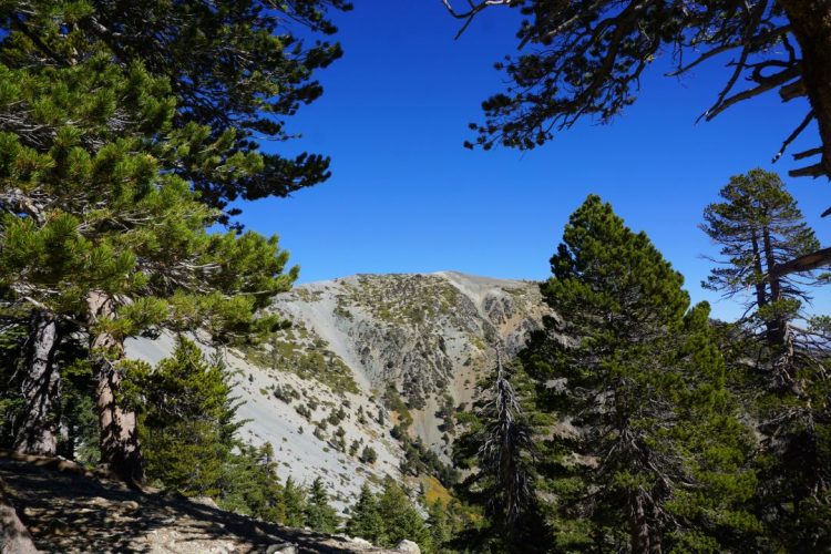
Okay, so I know that it’s a bit far from the SCV, but I think that Mt. San Antonio deserves to be on this list. If only for it’s reputation, every Santa Clarita hiker should pay a visit to Mt. San Antonio (AKA Mt. Baldy).
At 10,046 Feet, Mt. San Antonio is the highest peak in Los Angeles County. From the cleft of a deep canyon, the trail to San Antonio travels up the steep slopes of the San Gabriel Mountains. Moving among granite boulders, barren alpine slopes, and above a 1940’s Plane Crash Site, hiking Mt. San Antonio is a grand old time.
Hiking San Antonio is challenging. Some of Santa Clarita’s harder hikes are good training for this trail, itself a warm up for some Sierra Nevada peaks.
Whether or not you’re at the apex of fitness, Mt. San Antonio is still one of the best trails around. Bring friends, because the views from the top are truly amazing, and worth sharing with good company.
Our Favorite Hiking Gear

The Hiking in Santa Clarita is diverse, beautiful, and underrated. To tackle these trails, you’re gonna need the right gear. Check out our list of our favorite hiking gear.
Each item has been trail tested, proving itself time and time again in numerous hiking conditions. This gear will help you hike better, faster, safer, and most importantly, make you look good!
- The Best Campsites Around Big Bear California - February 26, 2021
- Hiking to the Hollywood Sign Via the Brush Canyon Trail - July 13, 2020
- Dirt Cheap Hiking and Backpacking Gear: The Most Affordable Gear on the Internet - July 4, 2020